
NASA’s NPOL radar in late May, located south of Waterloo, Iowa, under a large anvil cloud with mammatus clouds. Copyright Brenda Dolan, Colorado State University.
If you want to study rainfall and floods to help improve satellite predictions of both, you couldn’t choose a better place this year than Iowa.
But Witold Krajewski and the researchers at the University of Iowa’s Iowa Flood Center didn’t know that last year, when they planned the project with NASA’S Goddard Space Flight Center.
Krajewski, the flood center’s director, was persuading NASA to base its study in Iowa because the state has no mountains and sea coasts, which sometimes make it difficult for radar to distinguish rainfall from other things. “We do have floods,” Krajewski says he told the NASA collaborators. “I wasn’t wishing for a flood, but I was saying this when we were in a drought.”
NASA took a chance, despite 2012’s dry weather, and it’s paid off with a rush of data that’s expected to improve computer forecast models’ ability to predict flooding. The study’s observational phase wraps up this week, after employing some powerful radar and a small army of rain gauges and soil moisture sensors.
Iowans and others have a chance to learn more about the program, called the Iowa Flood Studies (IFloodS) at 1 p.m. CDT tomorrow (June 11) at a Google hangout with Krajewski, officials from NASA and the National Weather Service and others.
If you can’t make that, there’s a similar webinar at 6 p.m. Tuesday with the Community, Collaborative Rain, Hail, and Snow Network (CoCoRaHS), a web of more than 18,000 volunteer scientists who record and monitor precipitation. You can register here, although I’ve been told this program is mostly aimed at teachers.
The sessions may serve to answer questions from northeast Iowans who may have seen the huge NASA NPOL and D3R radar antennae south of Waterloo, or the flood center’s four XPOL radars mounted on flatbed trailers near Iowa City, Cedar Rapids, Calmar and Elkader. They also may have seen high-tech rain gauges, looking a little like white trash cans, holding lonely vigils in farm fields and near streams.
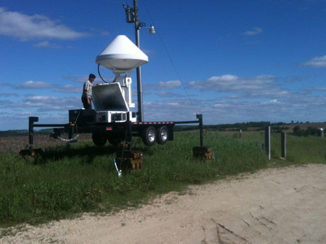
University of Iowa graduate research assistant Vijay Mishra performs maintenance on the Iowa Flood Center’s X-Band radar in the Turkey River basin. Credit: Matt Schwaller/ NASA
Since May 1, the flood center, NASA and the federal Agricultural Research Service (ARS) has set out these instruments to study three eastern Iowa regions: the Cedar and Iowa river basins, the south fork of the Iowa River, and the Turkey River basin. The study wraps up this Saturday; the NASA radars – and the scientists operating and overseeing them – then will pack up and go.
The goal, Krajewski says, is to combine and compare space-based and ground-based observations to build computer forecast models better able to predict rainfall and flooding – “specifically, to improve and evaluate the quality of space-based techniques for mapping rainfall.”
The project is particularly targeted at refining the radar and algorithms to be used in NASA’s Global Precipitation Measurement (GPM) project, a satellite mission to measure Earth’s precipitation from space every three hours. GPM’s core satellite, a partnership between NASA and the Japanese Aerospace Exploration Agency, is to launch in early 2014. The satellites should help scientists better understand Earth’s water and energy cycles.
The ARS, meanwhile, is focusing particularly on the Iowa River’s south fork as part of the NASA Soil Moisture Active Passive (SMAP) project to directly measure surface soil moisture and freeze-thaw cycles, helping improve forecasts of drought, floods and other weather.
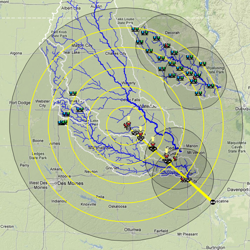
IFloodS map showing instrument location, including radar antennae, rain gauges and soil moisture probes.
This map shows the placement of rain gauges, soil moisture probes and other instruments. Each circle shows the approximate range of the radar antennae, with the yellow circles giving the range of the powerful NPOL and less powerful D3R devices. The smaller circles mark the ranges of the flood center’s XPOL radars.
“The idea here is to look at the range effects from those radars … as you go further from the radar, how does the performance change?” Krajewski says. “Here, it’s not just about estimating rainfall quantity. … All these ground-based instruments have the ability to observe individual raindrops.”
The radar, in other words, can distinguish raindrops of different sizes and their distribution, he adds. That “determines the performance of these different algorithms” to calculate rainfall from space-based instruments.
“For the Iowa Flood Studies, there was this additional factor that this mapping rainfall from space is not a goal in itself,” Krajewski says. “It has to serve the applications” of forecasting floods, flash floods and other disasters, “but more generally water resource management.”
With the survey finishing this week, the real work begins: analyzing the results. “I call this a goldmine of data,” Krajewski says, “because as far as these campaigns go, this one was the most successful” in yielding information.
As northeast Iowans along flooded streams will attest, “we had something happening almost every day” in the weather. “Everybody was very busy, but there is plenty of data – rainfall data, stream-flow data, soil moisture data.”
Analysis may take years, but for NASA, there is some urgency. Their researchers already are looking at the IFloodS results to improve the GPM satellite’s algorithms. “This data they collected here allows them to take another look at what they’ve come up with so far and maybe” make tweaks, Krajewski says.
The IFloodS project also is a boon for the Iowa Flood Center, he adds. Iowa lawmakers founded it in 2010 in response to the 2008 Iowa floods. Its mission is to research flood hazards and educate citizens. “Because of our scientific relationships and partnerships, such as IFloodS, we are bringing expertise from other scientists throughout the country, and in some cases from the world, to work on data from Iowa. That ultimately will help us as well.”


[…] issued a follow-up to their Global Precipitation Measurement mission in eastern Iowa. When I wrote about this in June, the researchers were tracking heavy rain and potential floods. In fact, just a couple days after I […]